View the Front Cover
View the Back Cover
Advertisers' Page
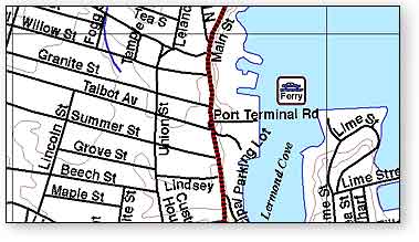
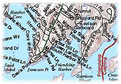
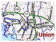
The Knox County Street Maps from Timestream® offer accurate street naming information for every town in the county. Lincolnville (in Waldo County) is also included because it is a member of the 5-towns Community School District (Camden Hills Regional High School) and because Lincolnville emergency services are dispatched by Knox County. The maps are formatted as a 44MB high-resolution PDF file (300dpi), printable as a complete 20-page book in 11" x 17" format or tiled and printed using Adobe Acrobat on 8.5" x 11" landscape pages. Detailed areas from these maps may be selected and printed separately using free Adobe Acrobat Reader software. Road and street names are printed in large bold type so the maps can be as small and handy as possible but still be easily read. Where streets are tight together, as in Rockland, Camden, and Thomaston, detailed enlargements are included. Contour lines and water features such as rivers and marshes are taken from USGS data. We included cemeteries, power transmission lines, and railroads. Each town's map also includes a key for looking up its roads. We felt this was particularly important because many roads in Knox County have only recenty been named, and even people "born and raised" in a town may not know where a "new" street is. Road and street names are printed in large bold type so the maps can be as small and handy as possible but still be easily read. Where streets are tight together, as in Rockland, Camden, and Thomaston, detailed enlargements are included. Contour lines and water features such as rivers and marshes are taken from USGS data. We included cemeteries, power transmission lines, and railroads. Each town's map also includes a key for looking up its roads. We felt this was particularly important because many roads in Knox County have only recenty been named, and even people "born and raised" in a town may not know where a "new" street is.
 In 1988, voters in the state of Maine approved a referendum to create an enhanced 9-1-1 system (e911) to ensure reliable caller information and improve dispatch of emergency services to readily identifiable locations. The plan required towns with rural route mailing addresses to convert them to city-style addresses (street names with numbers), and each town appointed a Municipal Addressing Officer to oversee the work of organizing the street names in his or her town and coordinating key players - residents, the town, the telephone company, and local Post Offices. In 1988, voters in the state of Maine approved a referendum to create an enhanced 9-1-1 system (e911) to ensure reliable caller information and improve dispatch of emergency services to readily identifiable locations. The plan required towns with rural route mailing addresses to convert them to city-style addresses (street names with numbers), and each town appointed a Municipal Addressing Officer to oversee the work of organizing the street names in his or her town and coordinating key players - residents, the town, the telephone company, and local Post Offices.
 At the Knox Regional Communications Center in Rockland (KRCC), where 911 telephone calls are answered, 35,359 incidents were fielded during the year 2003. Soon, computers will not only immediately provide the name and address of where the incoming telephone line is located, but they will link that address to a state-wide geographical information system (GIS), and a computer-generated street map will be shown on the dispatcher's screen to help send the proper emergency response to the proper place. At the Knox Regional Communications Center in Rockland (KRCC), where 911 telephone calls are answered, 35,359 incidents were fielded during the year 2003. Soon, computers will not only immediately provide the name and address of where the incoming telephone line is located, but they will link that address to a state-wide geographical information system (GIS), and a computer-generated street map will be shown on the dispatcher's screen to help send the proper emergency response to the proper place.
911 calls from cellular phones are not received directly by KRCC. Rather they are managed by State Police dispatchers in Augusta who relay what information they can get from the caller to KRCC. 911 hangup calls are always followed up, usually by a sheriff's deputy... 911 calls are taken seriously, and the County's e911 service has been of great benifit to the community.  Writing street names along highways, roads, streets, lanes, alleyways, and paths on giant maps has been an arduous task for each town's Municipal Addressing Officer. Sometimes naming streets in Knox County became hotly emotional and political. The final street names on these working maps were then sent to the State of Maine's geographical information system office, where they were digitized and added to Maine's GIS database. Writing street names along highways, roads, streets, lanes, alleyways, and paths on giant maps has been an arduous task for each town's Municipal Addressing Officer. Sometimes naming streets in Knox County became hotly emotional and political. The final street names on these working maps were then sent to the State of Maine's geographical information system office, where they were digitized and added to Maine's GIS database.
|
